Dr. Brad Muller
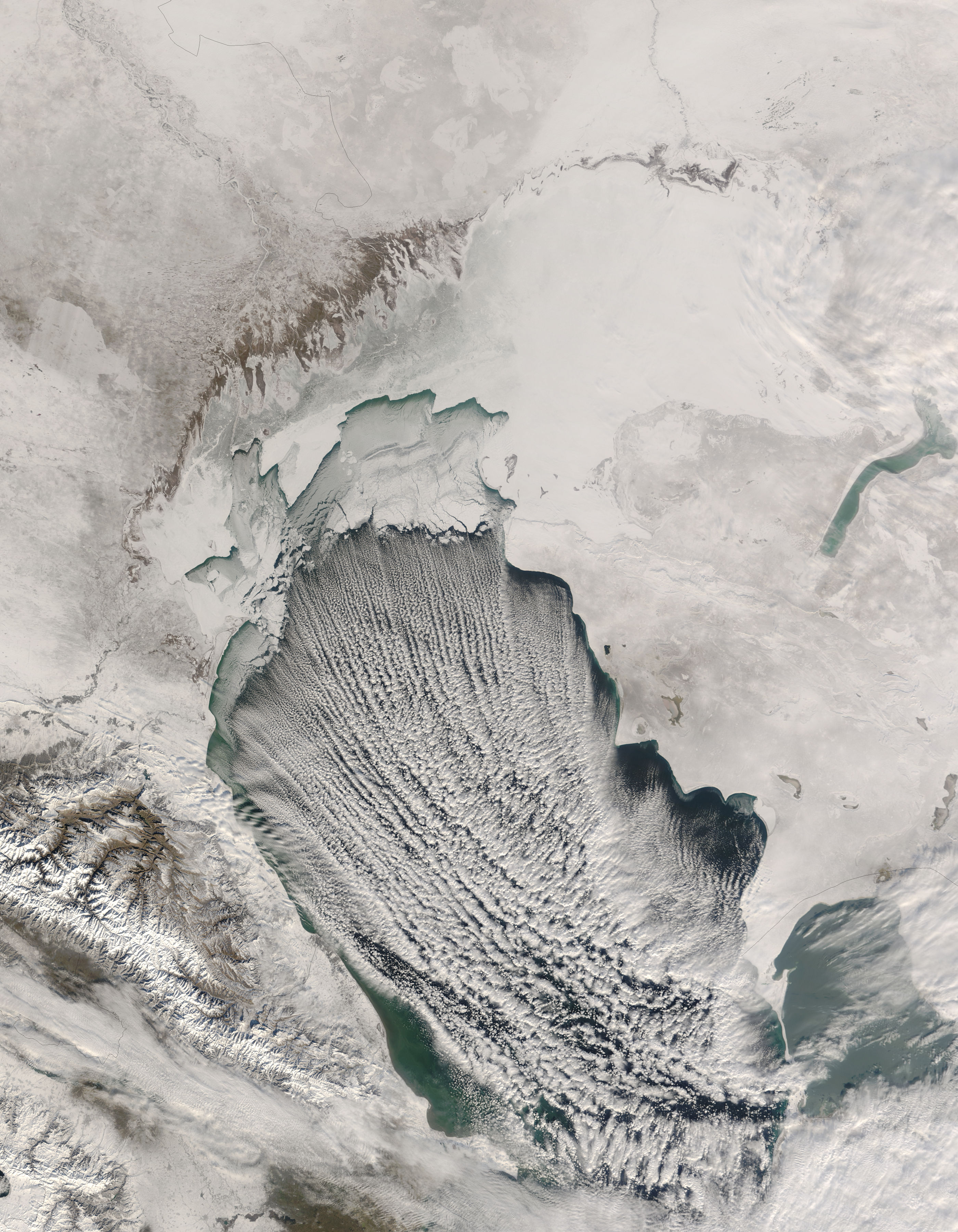
Cloud streets are lines
of
relatively low-level
cumulus
or towering cumulus clouds that tend to line up with the
wind direction
or with the wind shear vector. According to Conway
(1997), they
line up with the wind direction during their early stages of
formation;
farther down wind they are aligned more with the wind shear,
rather
than the wind direction itself (see Figs. 7.1-7.5).
They are an example of horizontal roll convection, that is, buoyantly rising air organizing into parallel, horizontal rolling motions in the atmosphere:
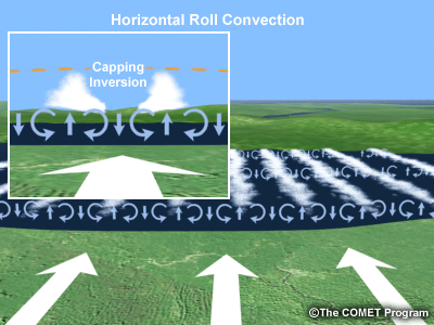
The source of this material is the COMET® Website at http://meted.ucar.edu/ of the University Corporation for Atmospheric Research (UCAR), sponsored in part through cooperative agreement(s) with the National Oceanic and Atmospheric Administration (NOAA), U.S. Department of Commerce (DOC). ©1997-2017 University Corporation for Atmospheric Research. All Rights Reserved.
They typically form under two different weather regimes that produce low-level convection:
(1) during the cold season when cold air moves over relatively warmer water, destabilizing the lower air layers and producing lines of convective clouds that usually are limited in vertical extent by a temperature inversion. Because they do not have high, cold tops, they do not appear bright on IR imagery.
They often can be seen off the east coast of the U.S. after a frontal passage during a cold air outbreak with northwesterly offshore flow. They also often can be seen over the Gulf of Mexico after a strong cold frontal passage, and over the Great Lakes during synoptic weather patterns that produce "lake effect" snow .
(2) During the warm season, cloud streets often can be seen over land surfaces as the sun heats up the ground producing cumulus clouds that more or less line up with the wind direction.
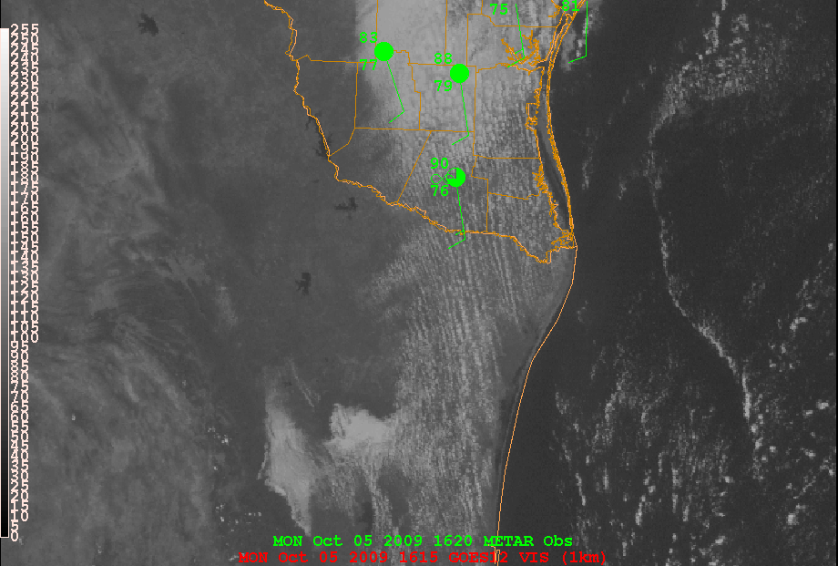
They are frequently seen during the warmer months over Florida, Texas, and much of the southeastern U.S. They are common almost any time of year over the Yucatan Peninsula.
A related phenomenon can often be seen in weather radar "clear air echoes" of horizontal convective rolls:
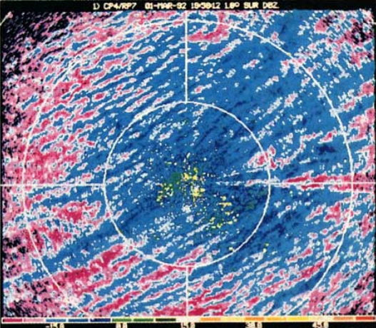
From Wilson et al., 1994:
https://doi.org/10.1175/1520-0426(1994)011%3C1184:BLCARE%3E2.0.CO;2
They are an example of horizontal roll convection, that is, buoyantly rising air organizing into parallel, horizontal rolling motions in the atmosphere:
The source of this material is the COMET® Website at http://meted.ucar.edu/ of the University Corporation for Atmospheric Research (UCAR), sponsored in part through cooperative agreement(s) with the National Oceanic and Atmospheric Administration (NOAA), U.S. Department of Commerce (DOC). ©1997-2017 University Corporation for Atmospheric Research. All Rights Reserved.
They typically form under two different weather regimes that produce low-level convection:
(1) during the cold season when cold air moves over relatively warmer water, destabilizing the lower air layers and producing lines of convective clouds that usually are limited in vertical extent by a temperature inversion. Because they do not have high, cold tops, they do not appear bright on IR imagery.
They often can be seen off the east coast of the U.S. after a frontal passage during a cold air outbreak with northwesterly offshore flow. They also often can be seen over the Gulf of Mexico after a strong cold frontal passage, and over the Great Lakes during synoptic weather patterns that produce "lake effect" snow .
(2) During the warm season, cloud streets often can be seen over land surfaces as the sun heats up the ground producing cumulus clouds that more or less line up with the wind direction.
They are frequently seen during the warmer months over Florida, Texas, and much of the southeastern U.S. They are common almost any time of year over the Yucatan Peninsula.
A related phenomenon can often be seen in weather radar "clear air echoes" of horizontal convective rolls:
From Wilson et al., 1994:
https://doi.org/10.1175/1520-0426(1994)011%3C1184:BLCARE%3E2.0.CO;2