General Circulation of the Atmosphere

"The world-scale systems of pressure and winds which persist throughout the year or recur seasonally. Such winds transport heat from tropical to polar latitudes, thus maintaining the present patterns of world temperatures.

"This global circulation is driven by intense differences in insolation between the tropical and polar regions, and is strongly influenced by the Coriolis force. Air moves vertically along the meridians and horizontally with the wind systems, both at ground level and in the upper atmosphere."


from "general circulation of the atmosphere." A Dictionary of Geography. Oxford University Press, 1992, 1997, 2004. Answers.com 14 Oct. 2011. http://www.answers.com/topic/general-circulation-of-the-atmosphere

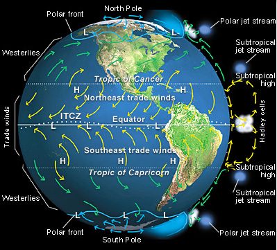
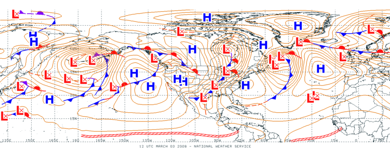
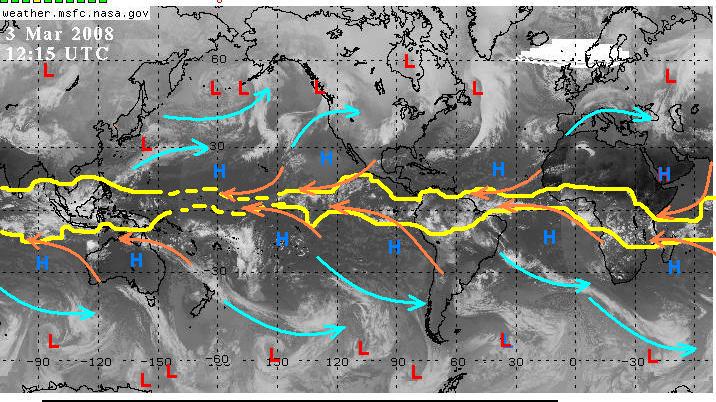
Features of the general circulation of the atmosphere represents the time-averaged winds and the time-averaged pressure systems over the entire earth's surface as well as the upper air.

These include:
  • Intertropical Convergence Zone (ITCZ) (it is the convergence of the northeast and southeast tradewinds at the equatorial lows and often results in calm winds; hence the term "doldrums"  from historical maritime terminology referring to sailing ships becalmed in this region for extended periods.
  • Northeast tradewinds
  • Southeast tradewinds
  • Westerlies
  • Polar front
  • Hadley cell
  • Subtropical highs (historical maritime terminology called these areas the "horse latitudes"...there are at least a couple of hypotheses as to the origin of that term--click on the link and see "etymology).
  • Subpolar lows--these are the mid-latitude extratropicalcyclones.

Some features of the general circulation:


A weather map at any given time is a snapshot of current conditions, and not the general circulation.  Nevertheless, the general circulation is a time average of many weather systems seen frequently on the the weather maps, so there should be correlations:


The same is true for satellite imagery--while a global composite is not a depiction of the general circulation, many of the features and air movements depicted on a satellite image or image animation are correlated with features of the general circulation.


Things to keep in mind for Exam 2, question 4:

1) the ITCZ varies in width and latitudinal position--it should not be depicted as just the region between two straight lines 20 degrees apart!

2) the northeast tradewinds blow from northeast to southwest on the south side of the northern hemisphere subtropical highs. You should depict circulation that is consistent with the position of the subtropical highs, i.e., anticyclonic circulation.

3) the southeast tradewinds blow from southeast to northwest on the north side of the southern hemisphere subtropical highs.
You should depict circulation that is consistent with the position of the subtropical highs, i.e., anticyclonic circulation

4) the ITCZ is the convergence zone between the northeast and the southeast tradewinds.

5) the subtropical highs show up as regions free of high, cold clouds (dark in IR; in VIS there is often extensive stratocumulus cover) between about 30oN and the ITCZ and 30oS and the ITCZ

6) the subpolar lows are seen as comma cloud features, with the low usually centered on the right (east) side of the comma head

7) the westerlies blow from west to east and can be thought of the anticyclonically curving cloud bands on the poleward side of the subtropical highs, completing the anticyclonic circulation around those highs, or as the anticyclonically curving jet stream cloud bands; they can also be thought of as the southern part (in the northern hemisphere, at least) of the cyclonic circulation around the subpolar lows