RADAR--Introduction

History of Weather Radar:

Early Radio Detection of Targets

Radar is an acronym that stands for RAdio Detection And Ranging.  Radio was invented during the late 1800s. Early radio users noticed that weather could affect performance, reducing transmission of radio waves.

However, the idea of using radio propagation to detect man-made objects was investigated before
anybody tried using it for weather detection.

As early as 1904, Christian Huelsmeyer patented an "early warning" system for ships to prevent collisions.

In 1922 it occurred to two radio engineers working on communications experiments for the navy that radio waves held the potential for remote detection of enemy ships: A steamer chugging up the Potomac River temporarily affected transmissions between a transmitter on one side of the river and a receiver on the other. The researchers, Albert Hoyt Taylor and Leo C. Young, proposed a system to protect harbors, but were ignored by the Navy and its Bureau of Engineering.  In 1930, Young and engineer Lawrence Hyland observed the effects of an aircraft on radio signals and notified Taylor of their results. By 1934 Taylor, Young, and Hyland had received a patent on a radar-like device for detecting aircraft.

While the first commercial ship-detection radar was produced in Germany in 1934, Britain created a more effective detection network for aircraft that helped them defeat a superior German air force during the Battle of Britain

Development of radar-like instruments occurred simultaneously in the U.S., Canada, Great Britain, France, Italy, Germany, Holland, Russia, and Japan, but World War II focused and accelerated radar development.

Early Research on Precipitation as a Target

It was not long before radar users noticed interference from weather systems masking targets of interest.  Specifically, precipitation particles caused radar echoes that could obscure echoes from objects.

Soon relationships between radar echo intensity and rainfall rates were discovered. The first work on quantitative relationships between precipitation and radar echo intensities is attributed to J. W. Ryde in Great Britain prior to 1941 (Ryde 1946).

Atlas and Ulbricht (1990) showed that Ryde's curves of drop size, reflectivity, and rainrate correspond to the relationship

Z=320R1.44
where Z is the radar reflectivity
and R is the rainrate

which, remarkably,  is virtually identical to a so-called Z-R relation apparently rediscovered and widely used around the world and in the NEXRAD (National Weather Service Doppler radar) rainfall algorithm.

Early research was conducted by J. S Marshall with project "Stormy Weather" sponsored by the Canadian Army Operational Research Group starting in 1943. After WWII his group moved to McGill University which is a center of cutting-edge weather radar research to this day.  Excellent correlation between radar reflectivity factor z (which is an inherent property of raindrop size distributions) calculated from observed drop samples and measured echo power (see Fig. below from Marshall et al. 1947)

inspired other researchers to work on development of weather radar and relationships between precipitation and radar echoes.

Operational Radar Networks are Developed in U.S.

It appears that the first use of radar for systematic detection of weather systems occurred during WW II.  In 1942 the U.S. Navy gave the U.S. Weather Bureau 25 surplus aircraft radars to be modified for ground meteorological use.

This figure shows early depictions of weather signatures in radar from 1943:

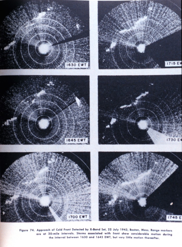
Approach of a cold front as observed on an X-Band radar set at Boston in July, 1943. This is perhaps the oldest preserved image of meteorological phenomena as observed by radar. In: "AAF Manual 105-101-2 Radar Storm Detection," by Headquarters, Army Air Forces, August 1945. Library Call Number M15:621.384 U58r.

line

space

Image ID: wea01246, Historic NWS Collection
Location: Boston, Massachusetts
Photo Date: 1943 July 22


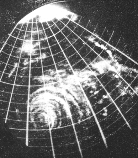
This figure is from Orlando in 1948 showing echoes of a hurricane:

Photograph of the radar scope at Orlando, Florida in 1948. This was the third time that a hurricane had passed sufficiently close to a radar site to have its structure revealed. In: "Weatherwise," Volume 1, No. 4, August 1948, p. 79.

Credits - NOAA Photo Library

Compare this image with a modern-day radar view of  Hurricane Charley in August 2004:


In 1956 the weather service proposed to congress and received budget increases for a warning network of the first generation of  Weather Surveillance Radars (WSR-57). The network was implemented in 1959 with the installation of 31 WSR-57s.  By the mid-1960's there were 45 radars around the U.S.

In the 1970s a second generation of weather surveillance radars, the WSR-74 was implemented to replace some of the WSR-57s, and also added in some new locations to fill in gaps in the radar network.

In the early 1990s the NEXRAD or "next generation" of weather surveillance radars was implemented, replacing  WSR-57s and WSR-74s with the WSR-88D.  The "D" stands for doppler.

The WSR-88D offers a number of improvements over the older generation radars: increased sensitivity for echo detection, the doppler capability of determining the radial velocity of moving targets, and many computer processing and display capabilities to enhance advance storm warning capabilities.

Radial velocity is the component of motion of an object either toward or away from the radar antenna, measured using the doppler shift of the radar frequency.

Locations of the NEXRAD network of WSR-88Ds can be found here.

Currently, precipitation echoes for the entire U.S. are available on the Internet in near-real time from this National Weather Service NEXRAD radar network. 

Here is an alternative view for aviation containing Radar Coded Messages  with echo top heights in hundreds of feet and movement in knots.

A view focusing on severe weather can be found here.