VIL is a NEXRAD radar estimate of the total amount of liquid precipitation water (in kg/m2 )in the atmospheric column over a given location. The amount of liquid precipitation water in a given volume can be calculated from the radar reflectivity using a so-called Z-R relation. The calculated liquid water content must be assumed to extend over the vertical column represented by a given elevation scan; then the amounts from each elevation scan at a given grid location can be summed up (integrated) vertically to obtain the total over that location. Note that the calculation assumes that the reflectivity is only from liquid water, not ice. Since hail can have very high reflectivity, it may cause the VIL calculation to overestimate the actual amount of liquid water; this means also that hail can yield very high VIL values.
VIL is most useful for severe thunderstorm detection and assessment because VIL is correlated with updraft strength which typically is correlated with storm severity (strong updrafts can hold up more water than weak updrafts, also typically are taller, and also is more likely to produce hail, all of which may contribute to higher VIL values) .
VIL is not available on the NWS NEXRAD page but is available on the ERAU Flight Weather NEXRAD Products page (click on the NEXRAD Products dropdown window, select VIL, then scroll down to the map and click on your desired NEXRAD station) and on the Weather Underground Radar Page (click on the link, then click on a specific radar, click on "Select Radar Type" button to upper left of PPI display, then scroll down to select "Vertically Integrated Liquid" under "More Information"). As far as we know, these are the only two web sites where VIL is available; as of Spring, 2014, a scale has been added to our imagery courtesy of Dr. Herbster).
VIL is available in GARP under NVL within the NIDS (NEXRAD Information Dissemination Service) Product Types window.
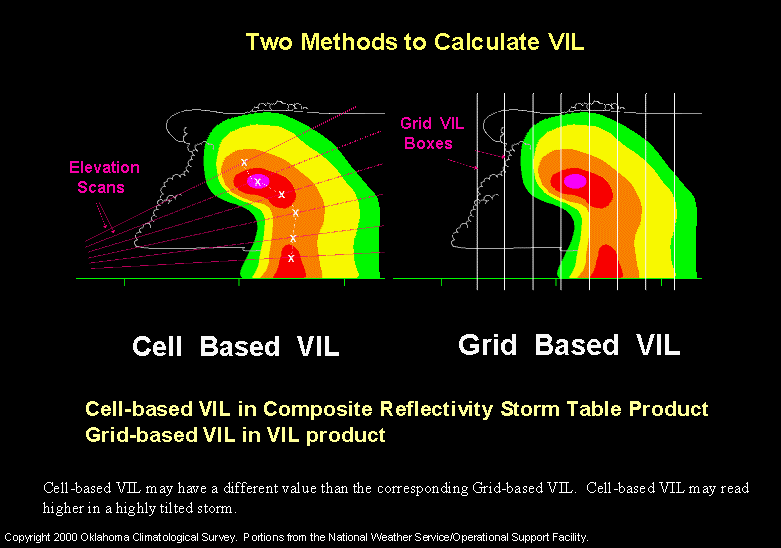
The figure below shows VIL calculated by two different methods: 1) a grid-based method (on the right) as mentioned above and 2) a cell-based method (on the left) that follows the cell vertically and might give more appropriate estimates for a severe storm with a tilted updraft.
(Note: some of following slides are from a web page on VIL by the Oklahoma Climatological Survey.)
Because high values of reflectivity are often correlated with large hail, high values of VIL also are correlated with large hail, and thus are often used to assess whether or not a storm is severe.
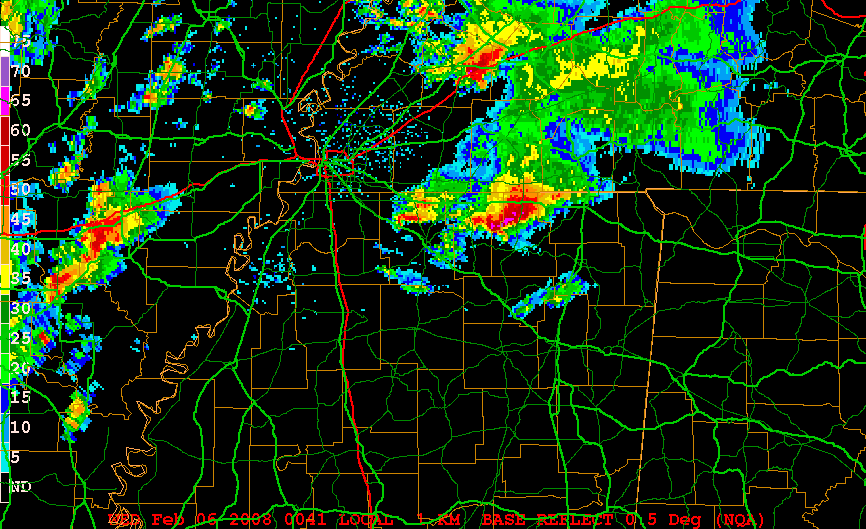
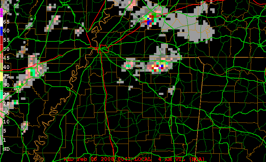
The following figure shows high reflectivity correlated with high VIL from the NEXRAD site at Memphis, Tennessee on February 5, 2008:
The following links show animations of the above example:
Memphis, TN Reflectivity, Feb. 5-6, 2008.
Memphis, TN VIL, Feb. 5-6, 2008.
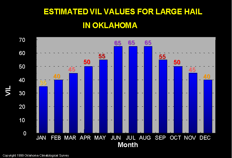
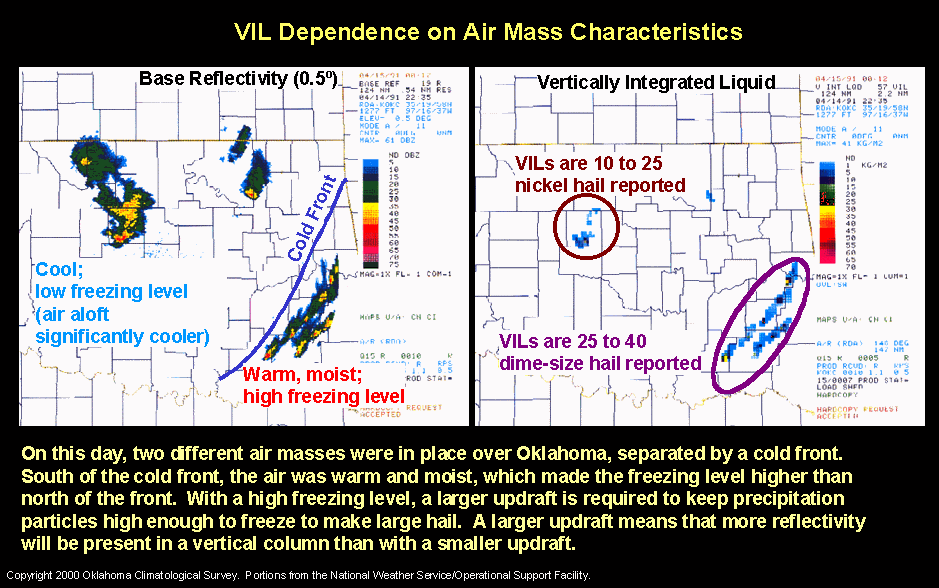
There is no single value of VIL that correlates to a specific-sized hail occurrence. The correlation is seasonally and air mass dependent, because VIL values correlate to the height of the storms as well as the intensity of the radar echoes. Cold season thunderstorms and cold air mass thunderstorms occur with a lower tropopause and thus have lower VIL values than warm season and warm air mass storms, thus they tend to be shorter vertically.
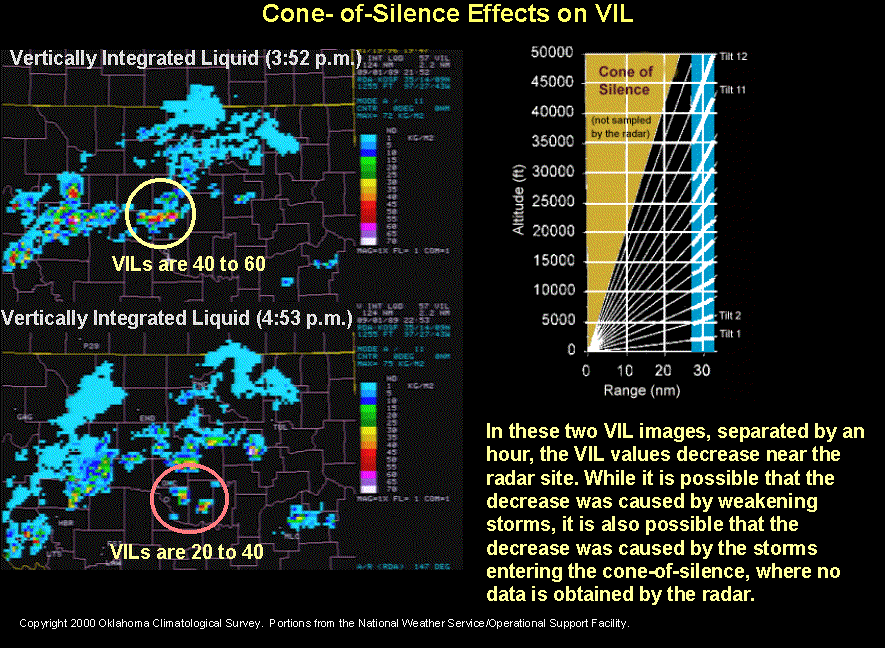
VIL can also be affected by the "cone of silence."
"VIL Density" has been proposed to mitigate the seasonal and temperature dependence; it "normalizes" the VIL by dividing by the height of the echo tops:
NWS Louisville--VIL Density as Hail Indicator