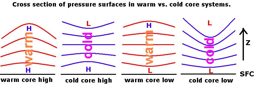
High pressure systems at the surface are not necessarily accompanied by high pressure aloft, nor are surface low pressure centers necessarily accompanied by low pressure aloft. It all depends on whether they are occurring primarily in warm or cold air.
Surface pressure systems can be classified according to whether they occur primarily in warm or cold columns of air. The distance between pressure surfaces is related to temperature through the Hypsometric Equation, derived from the hydrostatic relationship. It tells us that pressure surfaces are farther apart when the air is warm (the warm column is vertically expanded) and closer together in cold air (the cold column is vertically compressed). Regardless of the type of pressure system at the surface, a high aloft occurs in warm air, and a low aloft accompanies cold air.
The different idealized types of surface pressure systems are summarized as follows:
1. Warm core high: High pressure at the surface in a warm column of air becomes more pronounced with height. A synoptic example would be a high pressure at the surface during a summer heat wave.
2. Cold core high: High pressure at the surface in a cold column of air becomes low pressure aloft. This might happen as a cold winter high pressure area follows a cold frontal passage. Occurs because the pressure surfaces are vertically close together in the cold air. The surface high pressure will be a relatively "shallow" system.
3. Warm core low: Low pressure at the surface in a warm column of air becomes high pressure aloft. Examples are thermal low pressure centers such as occur in the hot Desert Southwest; also, tropical storms and hurricanes. These storms achieve their greatest intensity near the surface, and weaken as you go up. Pressure surfaces are vertically far apart in the warm air. The thermal low pressure is a relatively "shallow" system.
4. Cold core low: Low pressure center at the surface becomes more pronounced with height. Midlatitude or wave cyclones are examples of this kind of system. These systems become more intense with height and thus are fundamentally different from tropical storms.
Cold core low pressure systems often are not oriented vertically as shown in the idealized figure above, but appear more like the vertical structure depicted below:
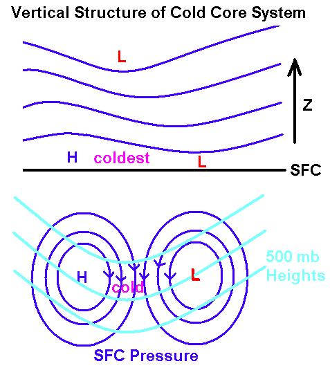
Note that the low at the surface slopes upward toward the west over the coldest air. The coldest air is coming southward in the cold advection region of northerly winds between the high pressure area and the downstream low pressure area. The 500 mb trough line is over the cold air to the west of the surface low.