Fill out the Form to Create a GIF animation
Legacy Graphics -
Surface Analysis
Surface Analysis w/ Satellite
Satellite and RADAR
Prog Charts
National Base Reflectivity RADAR Mosaic
National Composite Reflectivity RADAR Mosaic
Florida Base Reflectivity RADAR Mosaic
Florida Composite Reflectivity RADAR Mosaic
# of Images
# of times to loop (0 for infinite)
How many ms to hold on first image
How many ms to hold on last image
How many ms to hold on each image
Choose One:
Display Only
Save Only
Please only push the button once
Forecast Graphics -
Fcst Sea Level Pressure
Fcst Visibility
Fcst IMC
Fcst Mtn Obscuration
Fcst Cloud Base/Ceiling
Fcst Clouds @ 5kFt MSL
Fcst Clouds @ 10kFt MSL
Fcst Clouds @ 18kFt MSL
Fcst Clouds @ 35kFt MSL
Fcst Cloud Top
Fcst Sfc Density Altitude
Fcst D Value @ 4kFt MSL
Fcst D Value @ 8kFt MSL
Fcst D Value @ 12kFt MSL
Fcst D Value @ 36kFt MSL
Fcst Icing Base
Fcst Sfc Wind and Snow/Rain Rate
Fcst Snow/Rain Rate
Fcst Concetive Precip
Fcst RADAR
Fcst Low Level Turb
Fcst Boundry Layer Depth
Fcst Low Level Wind Shear
Fcst Gust
Fcst Gust Factor
Fcst 24hr Temp Change and Sfc Wind
# of Images
# of times to loop (0 for infinite)
How many ms to hold on first image
How many ms to hold on last image
How many ms to hold on each image
Choose One:
Display Only
Save Only
Please only push the button once
Wide Format Graphics -
Fcst Visibility - Wide
Fcst IMC - Wide
Fcst Cloud Base - Wide
Fcst Cloud Top - Wide
Fcst Density Altitude - Wide
Fcst Sfc Wind and Snow/Rain Rate - Wide
Fcst Rain/Snow Rate - Wide
Fcst RADAR - Wide
Fcst Mtn Obscuration - Wide
Fcst Low Level Turb - Wide
# of Images
# of times to loop (0 for infinite)
How many ms to hold on first image
How many ms to hold on last image
How many ms to hold on each image
Choose One:
Display Only
Save Only
Please only push the button once
NOAAPort Satellite -
Arctic
GOES 13
GOES 15
Sounder
GOES East CONUS
GOES East Florida
GOES West
CONUS Composite
NW Hemisphere Composite
Expanded CONUS
MDR
Mollweide
# of Images
# of times to loop (0 for infinite)
How many ms to hold on first image
How many ms to hold on last image
How many ms to hold on each image
Choose One:
Display Only
Save Only
Please only push the button once
ERAU Satellite Products-
US Sector Wide
Tampa Sector Wide
GOES East Wide
GOES West Wide
US Sector
Mid-Atlantic
Midwest
Gulf of Mexico
Puerto Rico
Tampa Sector
Daytona Beach Sector
Denver Sector
Caribbean
Western Atlantic
Tropical Atlantic
Eastern US
Gulf of Mexico
Eastern Canada
Western Hemisphere
Hawaii
Alaska
# of Images
# of times to loop (0 for infinite)
How many ms to hold on first image
How many ms to hold on last image
How many ms to hold on each image
Choose One:
Display Only
Save Only
Please only push the button once
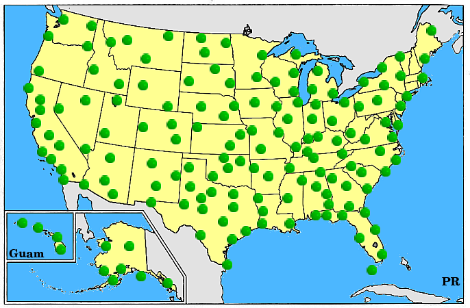
RADAR Stations -
Click station on map or select from list below
ABC
ABR
ABX
ACG
ADW
AEC
AHG
AIH
AKC
AKQ
AMA
AMX
APD
APX
ARX
ATL
ATX
BBX
BGM
BHX
BIS
BLX
BMX
BNA
BOS
BOX
BRO
BUF
BWI
BYX
CAE
CBW
CBX
CCX
CLE
CLT
CLX
CMH
CRP
CVG
CXX
CYS
DAL
DAX
DAY
DCA
DDC
DEN
DFW
DFX
DGX
DIX
DLH
DMX
DOX
DTW
DTX
DVN
DYX
EAX
EMX
ENX
EOX
EPZ
ESX
EVX
EWR
EWX
EYX
FCX
FDR
FDX
FFC
FLL
FSD
FSX
FTG
FWS
GGW
GJX
GLD
GRB
GRK
GRR
GSP
GUA
GWX
GYX
HDC
HDX
HGX
HKI
HKM
HMO
HNX
HOU
HPX
HTX
HWA
IAD
IAH
ICH
ICT
ICX
IDS
ILN
ILX
IND
INX
IWA
IWX
JAX
JFK
JGX
JKL
JUA
KJK
KSG
LAS
LBB
LCH
LGX
LIX
LNX
LOT
LRX
LSX
LTX
LVE
LVX
LWX
LZK
MAF
MAX
MBX
MCI
MCO
MDW
MEM
MHX
MIA
MKE
MKX
MLB
MOB
MPX
MQT
MRX
MSP
MSX
MSY
MTX
MUX
MVX
MXX
NKX
NQA
OAX
ODN
OHX
OKC
OKX
ORD
OTX
PAH
PBI
PBZ
PDT
PHL
PHX
PIT
POE
PUX
RAX
RDU
RGX
RIW
RLX
RTX
SDF
SFX
SGF
SHV
SJT
SJU
SLC
SOX
SRX
STL
TBW
TFX
TLH
TLX
TPA
TUL
TWX
TYX
UDX
UEX
VAX
VBX
VNX
VTX
VWX
YUX
Base Reflectivity
Storm Relative Velocity
Radial Velocity
Composite Reflectivity
Total Precipitation
VIL
# of Images
# of times to loop (0 for infinite)
How many ms to hold on first image
How many ms to hold on last image
How many ms to hold on each image
Choose One:
Display Only
Save Only
Please only push the button once