NEXRAD, also known as the WSR-88D is the radar network operated by the National Weather Service (NWS). Some installations also are operated by the Department of Defense and the FAA.
As previously noted, WSR-88D stands for Weather Survellance Radar; 1988 is the year it was commissioned, and D stands for Doppler.
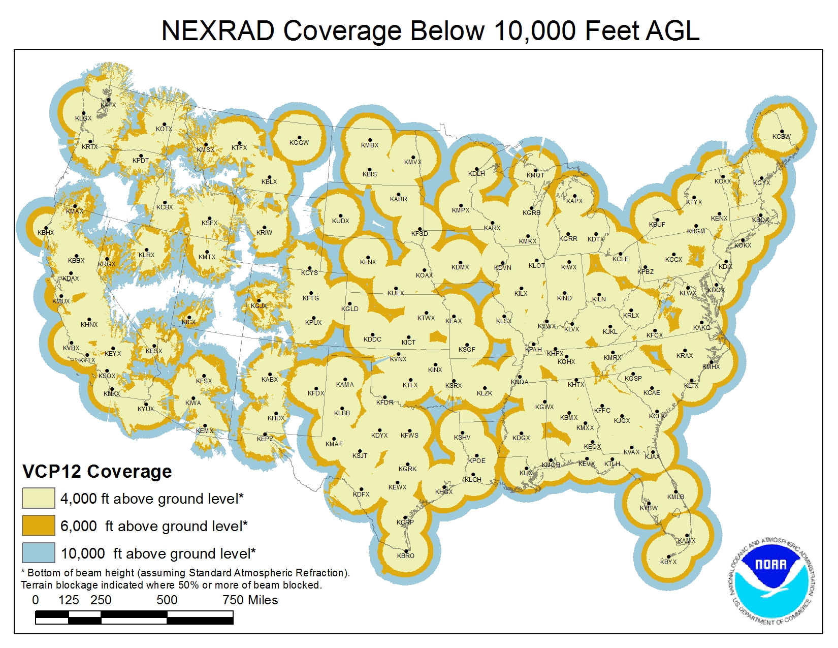
NEXRAD locations and their coverage in the continental U.S. are shown below:
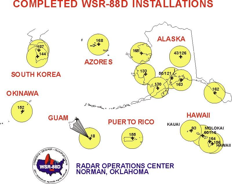
NEXRAD locations outside the continental U.S. are shown below:
Some of the basic NEXRAD specifications are reported here.
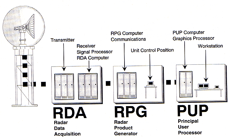
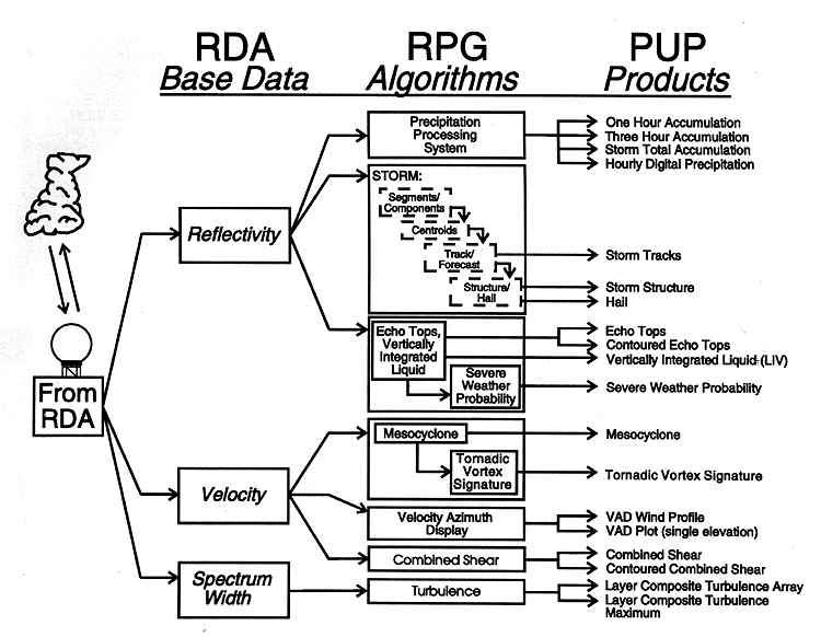
Functional components of the NEXRAD system include Radar Data Acquistion (RDA), Radar Product Generation (RPG), and the Principal User Processor (PUP). These components are illustrated below and described here:
Bull. Amer.
Met. Soc., © AMS, 1993
andWSR-88D data are partitioned into four levels generated in the three functional components above.
This link describes the pre-dual polarizaton data types while the following figure illustrates how they related to the functional components:
Bull. Amer. Met. Soc., © AMS, 1993
andWSR-88D data are partitioned into four levels generated in the three functional components above.
This link describes the pre-dual polarizaton data types while the following figure illustrates how they related to the functional components:
Bull. Amer. Met. Soc., © AMS, 1993
Level II Data:
After the dual polarization upgrade to NEXRAD completed in 2013, Level II data now include the three base data products plus three dual polarization variables (Federal Meteorological Handbook-11, Part A, p. 6, 2016):
"Level II Data. Digital radial base data (Reflectivity, Mean Radial Velocity, and Spectrum Width)
and Dual Polarization variables (Differential Reflectivity, Correlation Coefficient, and Differential
Phase) output from the signal processor in the RDA. The output also includes status information
required to properly interpret the data (e.g., information on synchronization, calibration, date, time,
antenna position, Nyquist velocity, and operational mode)."
Base Variables
Base Reflectivity: Corresponds to the strength of echoes backscattered to the antenna--related to the intensity of precipitation (and sometimes non-precipitation targets including insects, bats, birds, chaff, or wind turbines). Reflectivity is usually presented in units of dBZ, that is, decibels of reflectivity (see the Radar Equation).
Base Velocity: Radial velocity of the targets in the radar beam at a given location, that is, the speed of motion only toward or away from the radar. Usually presented in knots, with positive values corresponding to outbound motion (motion away from the radar) being represented by red or "warm" colors, and negative values corresponding to inbound motion (motion toward the radar) being represented by green or "cold" colors.
Base Spectrum Width: A measure of the variability of the radial velocities of individual targets (usually billions of raindrops) within the sample volume of the radar beam at each pixel.
Dual Polarization Variables
Differential Reflectivity: The difference between the return signal from the horizontally polarized portion of the beam and that from the vertically polarized portion.
Correlation Coefficient: The correlation between the return signal from the horizontal and vertical polarizations.
Differential Phase: The difference in the returned phases of the horizontally and vertically polarized signals due to propagation through the mass of targets.
Level III Data:
Level III data are derived from Level II data using computer processing algorithms in the RPG. There are more than 70 Level III products.
This link illustrates ranges of the 88D for various different radar products.
Radar Beam
Main beam--click here.
Sidelobes--click here.
Modes of Operation
The WSR-88D can operate in a precipitation mode or a clear-air mode.
Clear-air mode uses fewer elevation scans and scans more slowly. It has greater sensitivity, and therefore often picks up non-precipitation echoes. It is sometimes used for viewing snow, because snow is less reflective of microwave radiation than is liquid precipitation.
Precipitation mode uses more elevation scans and scans more rapidly.
Volume Coverage Patterns (VCPs)
The radar operates by scanning 360 degrees around the horizon pointing at various different elevation angles. The pattern of rotation speeds, elevation angles, and number of scans is called a Volume Coverage Pattern. Volume Coverage Patterns are described here.
There is a specific set of VCPs for clear-air mode, and a different set for precipitation mode.
Exercise
Reboot to LINUX and open GARP. Also, in a separate workspace open the Firefox browser, and go to the NOAA NEXRAD page. You will examine radar signatures in both clear-air mode (any VCP starting with "3") and precipitation mode (any VCP not starting with "3"):
Precip. mode:
1. First, using the browser, go to the above NOAA NEXRAD page.
2. Click on an area with apparent precip. in range of the station.
3. Find and note the three letter identifier for that radar, confirm that the VCP # begins with a "1" or a "2," and note the VCP.
4. In GARP, click the upper left button like for satellite imagery, but go either to NIDS, or NIDS-archive.
5. Under "Data Scale" find the 3-letter station identifier (arranged alphabetically in columns--use the scroll bar on the right to avoid skipping over stations in this awkward graphical interface!)
6. For the "Product Type," pick N0Q (again, arranged alphabetically in columns), the base reflectivity from the lowest (0.5 degrees) scan angle.
You should see coherent areas of precip. moving through the radar range, and you may see a bluish-grey "speckled" area in the vicinity of the radar itself if there is not precipitation there. The speckles are ground clutter and tend to "sparkle" as the loop progresses.
Clear-air mode:
1. First, using the browser, go to the above NOAA NEXRAD page.
2. Click on an area without precipitation in range of the station.
3. Find and note the three letter identifier for that radar, confirm that the VCP # begins with a "3," and note the VCP.
4. In GARP, click the upper left button like for satellite imagery, but go either to NIDS, or NIDS-archive.
5. Under "Data Scale" find the 3-letter station identifier (arranged alphabetically in columns--use the scroll bar on the right to avoid skipping over stations in this awkward graphical interface!)
6. For the "Product Type," pick N0Q (again, arranged alphabetically in columns), the base reflectivity from the lowest (0.5 degrees) scan angle.
This time you should see only the "speckled" area of "ground clutter" in the vicinity of the radar itself. Again, the pattern tends to "sparkle" as the loop progresses, but since clear-air VCPs are a more sensitive mode of operation, the ground clutter is usually more prominent and extensive than for precip. mode VCPs.