Emissivity
All substances emit radiation with an intensity proportional to the fourth power of temperature according to
the Stefan-Boltzmann law. However, the Stefan-Boltzmann law
represents the maximum radiant exitance
of a substance at each wavelength for any given temperature. Energy emitted from such a substance is
normally referred to as blackbody radiation. Most substances fail to reach this theoretical maximum
radiative intensity. In order to compare the actual to theoretical emission, a concept called
emissivity is defined. It is simply the ratio of the actual emitted radiance to that of
an ideal blackbody at the same temperature.
Emissivity ranges from 0 to 1 where 1 would be a blackbody. The emissivity can also vary
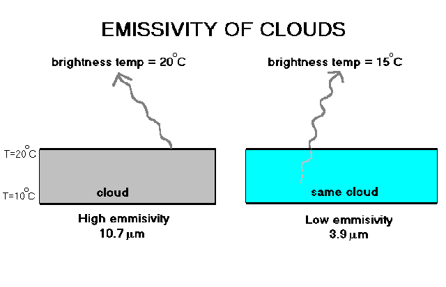
with wavelength for any particular substance. For example, the emissivity for water droplet
clouds decreases as the wavelength decreases from 10.7 µ m to 3.9 µ m. When viewing
a cloud, a sensor can penetrate further into its interior with the 3.9 µ m imagery compared to that
of the 10.7 µ m channel. The reason is that substances that are poor emitters are also poor
absorbers for any given wavelength. This concept describes Kirchoff's Law which states that in the infrared
portion of the electromagnetic spectrum, the spectral emissivity of an object generally equals its spectral absorptance.
Therefore, a cloud that has low emissivity also has low absorptivity and any emitted radiation within the cloud has a good
chance of escaping. If a substance has differing values of emissivity and absorptivity then the
temperature of the substance would change. More absorption than emission would lead to
temperature increases and the opposite is true. But for an object in local thermodynamic equilibrium
(or constant local heat content) Kirchoff's law stands. Coming back to the example between the 10.7 µ m to 3.9
µ m channels, we can observe differing brightness temperatures in a cloud from one channel to another because of
how far a sensor can penetrate into a cloud. The
only requirement is that the cloud must have some vertical temperature gradient as shown above.
Radiation originating from within the cloud must be emitted at a different temperature than radiation emitted from
the the cloud top surface.
Real applications come out of comparing satellite channels whose subjects have differing emissivities.
Shown below is an image taken from the AVHRR
instrument during a flash flood case in Southeast Texas.
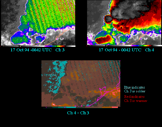
The upper left hand image is the
3.9 µ m channel (Ch3) while the upper right is the 10.7 µ m channel (Ch4). Both images have a rainbow top
enhancement which assigns colors to those cloud tops which have temperatures
below -20 º C. In the Ch4 image, the region displaying a transition from black to gray to white cloud tops within
the colorized region indicate cloud top temperatures below -70 º C showing the location of the most intense thunderstorms.
Note that Ch3 radiant temperatures are much warmer on average than the radiant temperatures of the thunderstorm tops displayed
in the Ch4 image.
When the difference between Ch4 and Ch3 radiant temperatures is taken, the result is the image on the bottom in the figure above.
The regions assigned a red color indicate where Ch3 radiant temperatures are warmer than the temperatures of the
thunderstorm tops in the Ch4 image. This most likely indicates that radiation is upwelling from lower levels in the
cloud where temperatures are warmer. However, sometimes the lapse rate indicates the presence of a
thermal inversion (temperature increases with altitude).
In those cases, the difference image displays a blue colorized region. The low clouds west of the thunderstorm are
an example of this. In most cases, fog and stratus occur in thermal inversions and this type of channel
differencing is very useful in delineating those regions.
Remember, the emissivity of clouds not only change with wavelength but also with cloud composition.
Go to front page